A Guide to the Most Stunning Photo Locations in Lake Tahoe
- Gabriella Viola

- Dec 5, 2018
- 6 min read
Updated: Dec 2, 2025

Want to know where some of the most beautiful spots in Lake Tahoe are? You’ve come to the right place! I’ve put together a list of some of the best photo locations in Lake Tahoe and how to find them. Let's get started….
P.S. Please enjoy Lake Tahoe responsibly. Always practice the Seven Principles of Leave No Trace.
Secret Cove


I'm not even going to save the best for last. Secret Cove is hands down one of the most, if not the most, photogenic spots in all of Tahoe. When the sun hits the cove just right, it creates a brilliant turquoise color that you have to see to believe.
Located off Highway 28 on Tahoe’s East Shore, it's easily accessible via a short hike from the main road or from Secret Harbor Parking Lot. Secret Cove is a clothing-optional beach, and you will more than likely see a few of the local naturalists sunbathing on the granite rocks along the beach.
Tip: Secret Cove is beautiful year-round, but it can get crowded during the summer months, especially on weekends. I find the best time to go is off-season, during the week, and in the late morning when the sun hits the cove just right to get that turquoise color. The water is also calmer during this time from a lack of activity, giving it a glass-like effect.
Secret Harbor Beach

Head south on the same trail that took you to Secret Cove, and you will find yourself at another spectacular beach spot in Lake Tahoe called Creek Beach. With its hues of turquoise, Creek Beach is reminiscent of the Caribbean. Like Secret Cove, Creek Beach is a clothing-optional beach that is mostly used by locals. It's a little more remote than Secret Cove, as a bit more hiking is involved to get here.
Tip: There is some hiking and a few boulders to cross to get to this beach. Sneakers or hiking shoes are recommended.
East Shore Coves

Along the east shoreline of Lake Tahoe between Chimney Beach and Secret Cove, you will find plenty of tranquil and picturesque little coves. The best part: You will most likely have the coves all to yourself. While most of the tourists are cramming into an overcrowded Sand Harbor during the summer months, you can have a serene and secluded little slice of Tahoe heaven all to yourself. Not only are these coves a great spot to take beautiful and unique photos, but they are also great for swimming.
Bayview Trail


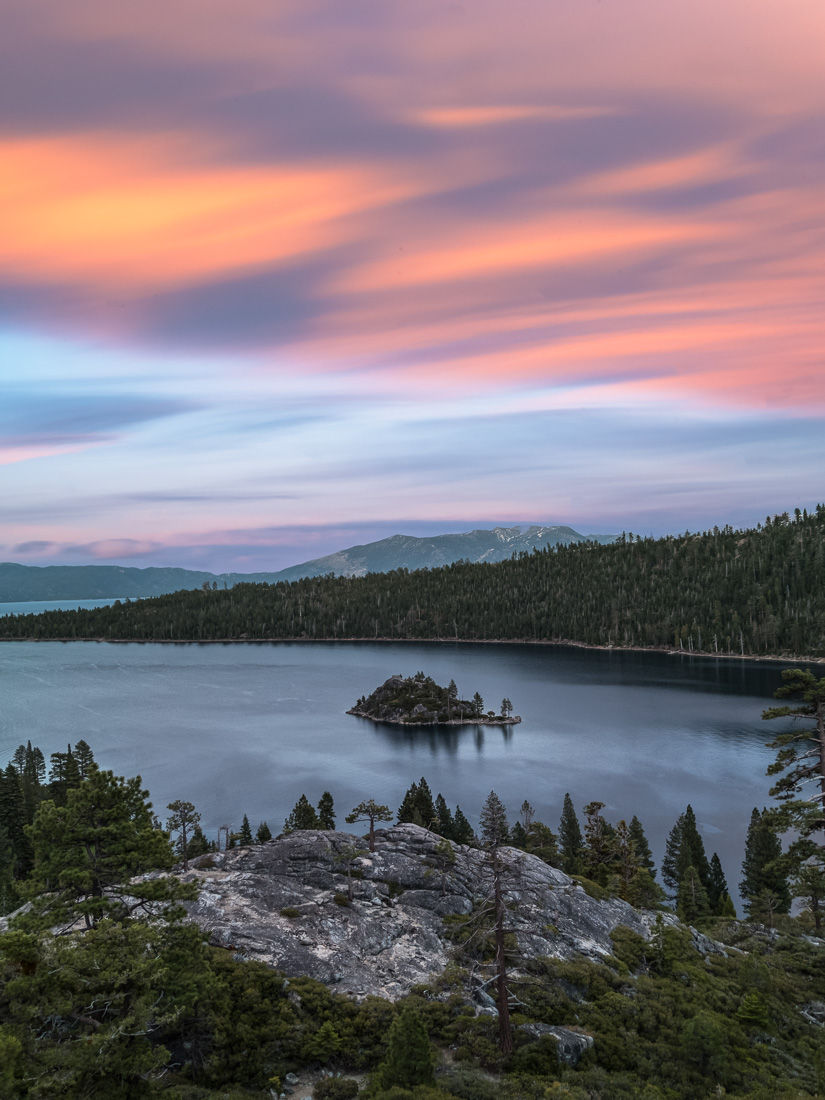
The Bayview Hiking Trail is a 5-mile trail through Tahoe's Desolation Wilderness. However, you don't need to hike that far; spectacular views of Emerald Bay can be reached within the first half-mile of the trail.
The entrance to the trail is located in Bayview Campground, which is right across the street from Inspiration Point on Highway 89. At the trailhead, you have the option to go left towards Cascade Falls or right towards Desolation Wilderness/Granite Lake. Head towards the right. After about half a mile on the trail, you will come to a ridge overlooking Emerald Bay. Once you've finished taking in the beautiful views, you can call it a day or continue on the trail towards Granite Lake and Maggie's Peak for more photo opportunities.
Emerald Bay

Emerald Bay is probably one of the most well-known and photographed spots in Lake Tahoe. It's located in the southwestern corner of the lake right off Highway 89. Although the view is similar, this spot is different from the one listed above as there is no hiking involved. Just pull right off the side of the road at one of the turnouts.
Tip: Most people stop at Inspiration Point to photograph the bay, but the best view is actually a little past Inspiration Point. Inspiration Point is pretty, but there are too many trees blocking the view of the bay. Drive a little past Inspiration Point and pull off the side of the road for an unobstructed view of Emerald Bay.
Monkey Rock


The hike to Monkey Rock is a relatively short but steep hike along the Flume Trail that offers some of the best views of Lake Tahoe. The trailhead is located behind the Tunnel Creek Cafe on Highway 28 in Incline Village. You’ll notice the views almost immediately, and they get better as you continue up the trail.
The trail itself is pretty self-explanatory. It starts as a paved road, then turns into a well-maintained dirt trail. The trail eventually splits; one route is steeper and faster and the other is slightly less steep, but both end up at the same point. Once you reach this point, head left and you will arrive at Monkey Rock.
Once at Monkey Rock, you may encounter some fellow hikers waiting their turn to get a photo with the Monkey. You can choose to take a photo with the monkey or find a nearby boulder to relax on, eat a snack, and enjoy the spectacular views.
Tip: Monkey Rock viewpoint has 360-degree views of Lake Tahoe, so don't forget to explore the south-facing views after photographing Monkey Rock.
Cave Rock

Who doesn’t love a super short hike with a great view? Cave Rock hike is a short, easy 0.8-mile hike that will take you under 15 minutes to get to the viewpoint. This hike is right over the rock tunnel on Highway 50. ( I've actually driven through the tunnel many times, completely unaware of the hiking trail right above it! ).
The trailhead is located on Cave Rock Drive right off Highway 50. Drive to the top of the road and the trailhead will be on your left; you can’t miss it. From the parking area, it takes about 12 minutes or so to reach the base of Cave Rock. Take in the views from the base or make an easy climb to the top of the rock for amazing 360-degree views of Lake Tahoe.
Tip: Cave Rock is a great spot to catch the sunset in Lake Tahoe. Hiking boots are also a good idea if you want to climb to the top of the rock.
Bonsai Rock

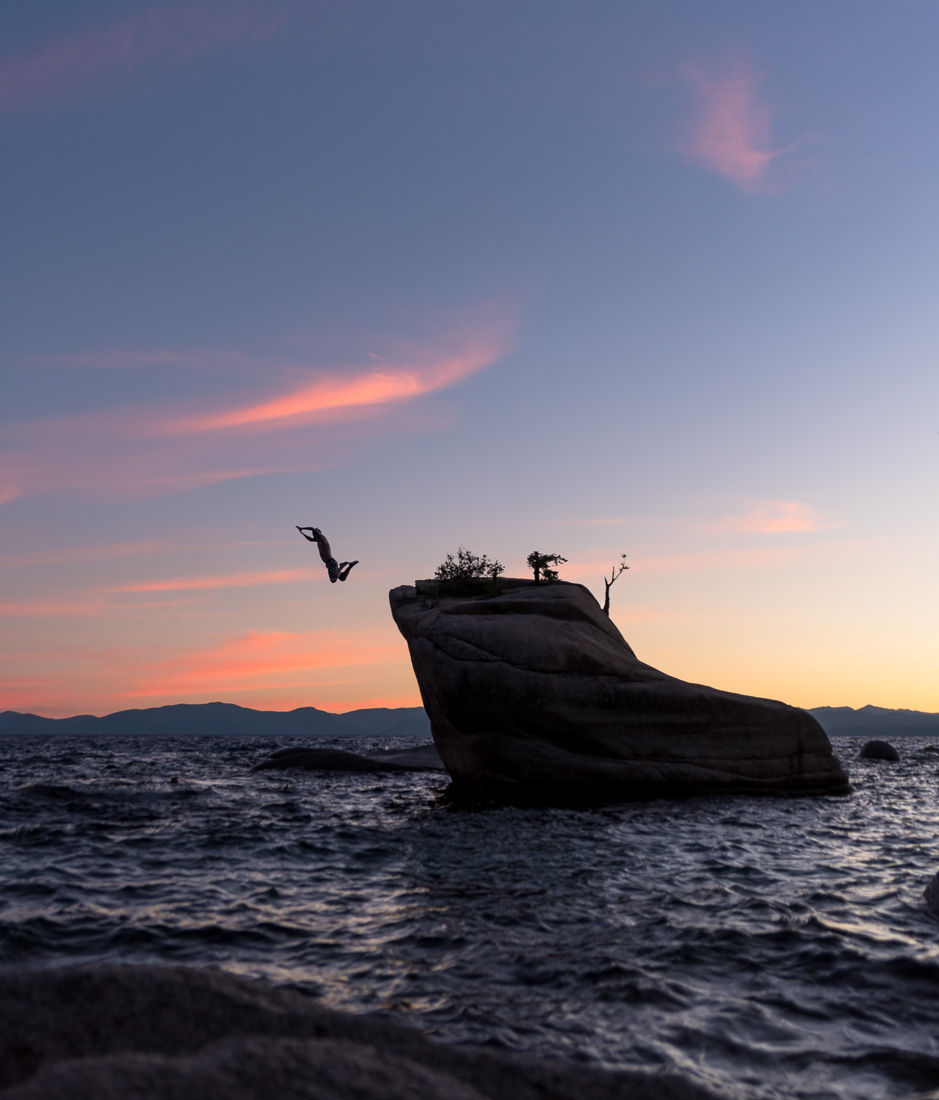
Bonsai Rock is a well-known spot in Lake Tahoe that attracts photographers and tourists alike. I'm not sure what makes Bonsai Rock itself so popular; perhaps it's the little tree growing out of it. Bonsai Rock is located off Highway 28 on Tahoe’s East Shore. Several short, semi-steep trails lead directly to the rock right from the highway.
Spooner Lake State Park

There is something special about Lake Tahoe in autumn. The summer crowds are gone, the lake is calm, and bursts of fall color are everywhere. But if you want to see TONS of fall color all in one place, look no further than Spooner Lake. The trails around Spooner Lake are known for their spectacular displays of fall color, and the best trail of them all is North Canyon Road. North Canyon Road is a picturesque trail that is lined on both sides with brilliant yellow and orange aspen trees. You don't have to walk very far; the fall colors hit you right at the start of the trail.
Tip: Fall color peaks early to mid-October
I hope this guide was helpful. What are some of your favorite places in Lake Tahoe? Leave a comment! Also, make sure to subscribe to the blog so that you don’t miss out on the latest blog posts, videos, and other good stuff.
WATCH THE VIDEO HERE:
You might also enjoy:
If you enjoyed this post or know someone who will find it useful,


